San Francisco Peaks
San Francisco Peaks

San Francisco Peaks

Flagstaff, Arizona, 86001

The basics

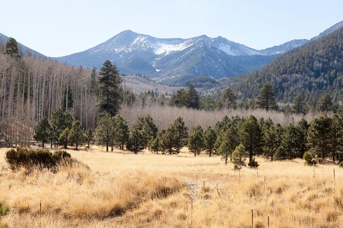
What was once the enormous San Francisco Mountain is now a collective of six summits surrounding a quiet caldera. With a 12,643-foot (3,853-meter) elevation, Humphreys Peak is its tallest summit, followed by Agassiz, Fremont, Aubineau, Reese, and Doyle Peaks. Winter playgrounds include Snowbowl, Flagstaff Nordic Center, and Wing Mountain. For a scenic drive, try the 70-mile Volcanoes and Ruins Loop, 44-mile Peaks Loop, 26-mile Schultz Pass Road, or 15-mile Snowbowl Road.

One of the most popular activities in the San Francisco Peaks is hiking, with several notable trails. Inner Basin Trail showcases beautiful meadows, fall colors, and lush, high-elevation scenery. For the adventurous, hikers can summit Humphreys Peak from the Snowbowl parking lot. Honor the importance of The Peaks to native populations by visiting Elden Pueblo, an ancient Sinagua village.

Visa alla

Things to know before you go

  • No matter the season, Arizona Snowbowl Ski Resort offers go-to access to The Peaks, with skiing, hiking, biking, fall color, and gondola rides.

  • The steep, 10.7-mile round-trip hike to Humphreys Peak does not require a permit, but a backcountry permit is required to camp on the summit or to access the peak during the winter.

  • The Kachina Peaks Wilderness Area—named for the deities that local indigenous peoples believe live in the San Francisco Peaks—encompasses the high-elevation portions of the mountains, including Humphreys Peak.

  • To get an excellent view of Humphreys Peak from Flagstaff, hit the 2-mile (3.2-kilometer) loop trail at Buffalo Park.

Visa alla

How to get there

The Peaks are located in the Coconino National Forest, and accessible by several Forest Service roads and highways. From Flagstaff, drive north on Highway 180. Continue north on Snowbowl Road to reach Arizona Snowbowl Ski Resort, Kachina Trail, and Humphreys Peak Trail. You can also take US 89, along with FR 420, for access to lower slopes. Use FR 552 for the easiest route into the Inner Basin.

Visa alla

When to get there

Whether you are looking for wildflowers, fall foliage, or a winter wonderland, all seasons have their beauty in The Peaks. Snowbowl's skiing season typically runs from late November to April—always check the local road conditions and bring chains or 4-wheel drive, if necessary. Head to Snowbowl in the summer or fall for a ride on the Scenic Gondola, with views of the Grand Canyon. Fall brings golden color to the aspen groves peppered throughout the mountains.

Visa alla

Hike a section of the Arizona Trail

The Arizona Trail cuts across 819 miles (1,318 kilometers) of the state, cut up into 43 passages. Passage 34 makes up the San Francisco Peaks Trail section, covering 35.3 miles (56.8 kilometers) from Schultz Pass to Cedar Ranch. Trekking through through the west side of the peaks, this trail meanders through lush meadows, pine forests, high desert, and aspen groves. A 15-mile (24-kilometer) round-trip section begins at Aspen Corner, halfway up the Snowbowl Road that rewards high-altitude difficulties with stunning scenery.

Visa alla
SV
8c6d207f-bc85-47e9-bd36-23d6edbc6257
attraction_detail_overview